Technical Specs
Introduce your location to the world.
Add the power of FastFacility GIS based technology to your website.
Powered by ArcGIS server, users will receive the most comprehensive view possible of your region. Simple to use GIS tools coupled with a familiar Bing interface ensures a powerful and robust GIS experience.

GIS Tools Simple, powerful tools to give the best GIS view of your community.
All FastFacility solutions offer advanced GIS functionality.
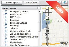
Unlimited Data Layers
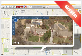
Bird’s Eye
Street View
Multiple Database Search
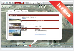
Available Real Estate Integration
Select Map Features
Radius Demographics (Drive Time & Distance)
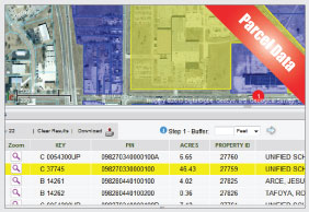
Buffering
Report Generation
Zoom
Measurement Tool
Identify Tool
Customized Inline Help
Printing/ Export Feature

Integrate your Data
Customize how the world will learn about your location and organization
Now you can add an unlimited amount of your own data as Layers to the map. Examples:
You can Supply:
Infrastructure Projects
Parcels Information
Public Transportation Routes
Real Estate
Recreation
Schools
Zoning
FastGIS can Supply:
Business Listings
Census Tracts
City Boundaries
Colleges/Universities
County Boundaries
Demographics
Urban Areas

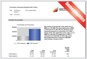
Radius Demographics
FastGIS can supply its custom high-quality radius and drive-time demographic data to your site at low cost.
FastGIS can add demographic data with estimates and projections to your website and GIS application.
Ancestry and Language Summary and Comparison
Demographic Summary and Comparison
Employment Summary and Comparison
Executive Summary Report with Charts
Housing Value Summary and Comparison
Population Comparison

Real Estate
Have your locations available Real Estate effectively marketed to Corporate End Users and Site Consultants.
FastGIS provides the best Real Estate database solution in the marketplace. Incredibly easy to manage, FastGIS makes it simple for agencies and your stakeholders to add or modify property listings, upload multiple images and graphics and maintain their listing inventory 24/7.
All properties uploaded to your FastGIS system are automatically uploaded on the globally marketed FastFacility.com.